This site requires cookies to be enabled in order to function correctly. These are functional cookies, and
are not used for marketing purposes.
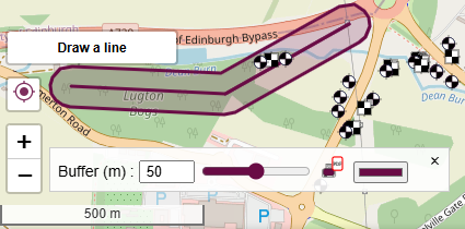
Cross-Sections
Activate the draw a line tool in the bottom left
(the button will turn yellow).
Click point-to-point to draw your line of section.
Use the tool-bar to change colour and buffer distance.
If you wish to enter specific coordinates,
use the input coordinates button.
If your holes are not showing in the section,
try extending the line by a meter either end.
Click on the line of section to see publishing options.
Or click the print button from the tool-bar.
Double click to end or start a new line.
Additional Maps
Sorry, you need to be logged in and hold a current paid or trial license to view historic maps and satellite
layers.


 Start Logging
 Print Logs and Reports
 Print Site Location Plan
 Download Data
 Settings & Logo
